THE DJI PHANTOM 4 PRO V1 or V2.0 PPK DRONE MAPPING SYSTEM
The DJI Phantom 4 Pro V1 or V2.0 PPK Drone Mapping System consists of three main components including (1) a DJI Phantom 4 Pro V1 and V2.0, (2) an Emlid Reach M+ GNSS receiver to be used for PPK integration and (3) an Emlid Reach RS+ GNSS receiver to be used a Base Station.
(1) DJI Phantom 4 Pro V1 or V2.0 Drone
The new Phantom 4 Pro V2.0 features an OcuSync HD transmission system, which supports automatic dual-frequency band switching and connects to DJI Goggles wirelessly. Like the Phantom 4 Pro and Advanced, the Phantom 4 Pro V2.0 is equipped with a 1-inch 20-megapixel sensor capable of shooting 4K/60fps video and Burst Mode stills at 14 fps. Plus, its FlightAutonomy system includes dual rear vision sensors and infrared sensing systems for a total of 5 directions of obstacle sensing and 4 directions of obstacle avoidance.
It has the following key specifications:
- Weight (Battery & Propellers Included): 1375 g
- Max Flight Time Approx.: 30 minutes
- Satellite Positioning Systems:GPS/GLONASS
- Max Wind Speed Resistance: 10 m/s
- Max Speed: 15 m/s
- Camera Sensor: 1’’ CMOS Effective pixels: 20M with Mechanical Shutter
- Gimbal Stabilization: 3-axis (pitch, roll, yaw)
- Remote Controller: Operating Frequency 2.400 - 2.483 GHz and 5.725 - 5.850 GHz ; Max Transmission Distance: up to 7km
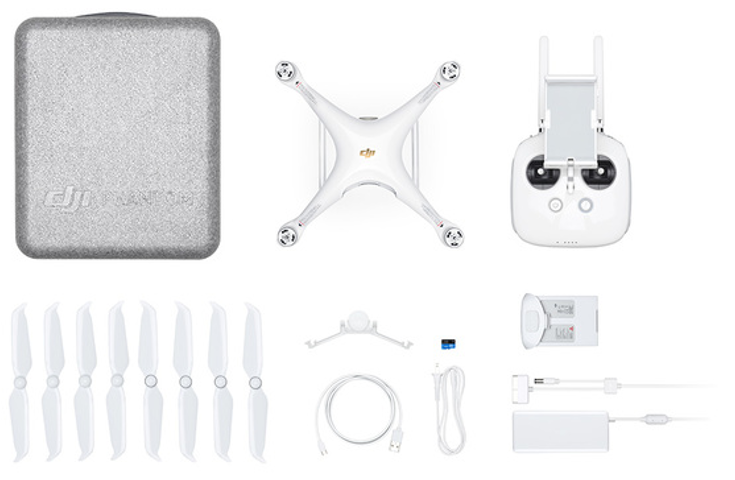
Photo of a DJI Phantom 4 Pro V1 and V2.0 drone package
(2) Emlid Reach M+ PPK GNSS Receiver
Usually autopilot triggers the camera and records the coordinate it has at the moment. When the drone is flying at 20m/s and GPS works at 5Hz, that means your autopilot will have position readings only each 4m. While enough for navigation such readings are not suitable for precise georeferencing. Also, there is always a delay between the trigger and the actual moment the photo is taken.
Reach M+ module solves this by directly connecting to the camera hot shoe port which is synced to the shutter. The time of each photo is logged with a resolution of less than a microsecond.
It has the following key specifications:
- Size: 56,4 x 45,3 x 14,6 mm
- Weight: 20 g
- Signal Tracking: GPS/QZSS L1, GLONASS G1, BeiDou B1, Galileo E1, SBAS
- Positioning Accuracy
- RTK/PPK: XY = 7 mm + 1 ppm ; Z = 14 mm + 2 ppm
- Static: XY = 5 mm + 1 ppm ; Z = 10 mm + 2 ppm
- RTK Connection: Radio + Internet (RTCM2.3/3.x, CMR, CMR+)
- PPK processing with easy to use software
.png)
Photo of an Emlid Reach M+ and its antenna
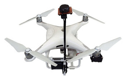
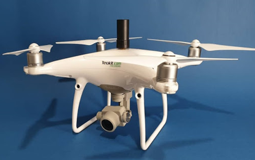
The PPK system can be integrated with drone as removable kit or as built-in integration as shown in the photos below:
|
|
|
|
Photo of removable kit |
Photo of built-in integration |
(3) Emlid Reach RS+ GNSS Receiver as Base Station
Reach RS+ is ever-ready to do surveying, mapping and data collection with centimeter accuracy. It is a rugged and versatile multi-GNSS RTK receiver with built-in IMU. It can provide coordinates down to centimeters in RTK mode. RTK mode requires a pair of receivers: one is stationary which provides corrections, another one moving which applies corrections and provides its precise coordinates. Reach has open-source RTK engine RTKLIB at its core and is controlled using cross-platform ReachView app. Thanks to large battery and built-in radio communication Reach RS+ is perfectly suited for field work.
When connected to the Internet ReachView will automatically check if a new version is available and show you a notification. Simply tap the update button to receive new features and advancements, no need to drive to your dealer for a new firmware version.
It has the following key specifications:
- Size: 56,4 x 45,3 x 14,6 mm
- Weight: 20 g
- Signal Tracking: GPS/QZSS L1, GLONASS G1, BeiDou B1, Galileo E1, SBAS
- Positioning Accuracy
- RTK/PPK: XY = 7 mm + 1 ppm ; Z = 14 mm + 2 ppm
- Static: XY = 5 mm + 1 ppm ; Z = 10 mm + 2 ppm
- RTK Connection: Radio + Internet (RTCM2.3/3.x, CMR, CMR+)
- PPK processing with easy to use software
- Battery life: 30 hours
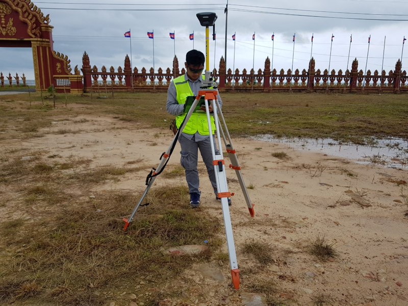
Photo of an Emlid Reach RS+ used as Base Station for drone mapping